Skip to content
Gemawan

Lembaga Gemawan

Self-Sufficient and Independent Society

Menu

  • Home
  • News
    • Women Empowerment
    • Community Based Development
    • Natural Resource
    • Economic Development
    • Good Governance
  • Publication
    • Report
    • Opinion
    • Attitude Statement
    • Book
  • Spatial
    • Map
  • About
    • Team
    • Programme & Activities
  • Innovation
    • LESTARI
    • PERSADA
    • SIGAP
  • Support SIGAP!

Spatial Planning

Community Participation in Spatial Planning of Tanjung Satai Village
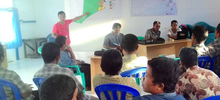
VERIFIKASI PETA: Fasilitator Pemetaan/GIS Gemawan, Welly Arma (kiri) memimpin verifikasi peta desa Tanjung Satai, bersama Kades Tanjung Satai Turaidi (kedua dari kanan), Kepala Distric Officer Gemawan KKU Agus Budiman (kanan), dan warga desa di Balai Desa Tanjung Satai, Jumat (17/06/2016). Foto: Welly Arma/GEMAWAN.

MAP VERIFICATION: The facilitator of Gemawan Mapping/GIS, Welly Arma (left) led the verification of Tanjung Satai village map, with the Village Head of Tanjung Satai, Turaidi (second from right), the District Officer Head of Gemawan in KKU, Agus Budiman (right),

admin July 21, 2016February 16, 2023 Community Based Development, Headline, Natural Resource, News Read more

Instagram

Collab!

Rumah Gesit Gemawan

Jl. Ujung Pandang No. 89
Pontianak | Kalimantan Barat | Indonesia
Telp.: (+62561)5628041
E-mail: info[at]gemawan.org
Pengaduan: lapor[at]gemawan.org

Connect!

Create!

PERSADA
LESTARI
SIGAP
#BorneoMangroveAction
SIGMA
Copyright © 2025 Lembaga Gemawan. All rights reserved. Theme Spacious by ThemeGrill. Powered by: WordPress.