")
The condition of Mempawah’s mangroves reveals a tale of two realities: on one hand, grassroots conservation efforts have revived optimism; on the other, relentless development continues to erode what remains of this vital ecosystem.
The mangrove forests of Mempawah stretch between mud and waves — a living wall that protects West Kalimantan’s coastline from the relentless sea. Beneath its dense canopy, fishers seek crabs, shellfish, and fish, while its tangled roots hold together the fragile balance of coastal ecosystems. Yet, amid rapid development and climate change, one question remains: what is the current state of Mempawah’s mangrove forests?
A recent study sought to answer this question. Using Sentinel-2A satellite imagery, Reza et al. (2025) examined changes in the extent and density of Mempawah’s mangroves over six years, from 2018 to 2024. The findings revealed a fluctuating trend—an initial increase followed by a subsequent decline.
Rising in 2021, Falling Again in 2024
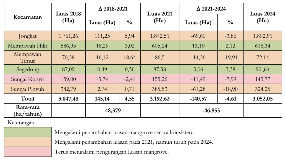
In 2018, the total mangrove area in Mempawah Regency was approximately 3,047 hectares. Three years later, it expanded to 3,192 hectares, marking a gain of around 145 hectares. Unfortunately, this growth was short-lived: by 2024, the coverage had dropped again to 3,052 hectares, nearly returning to its original size.
This change, however, was not uniform across the region. Two sub-districts—Segedong and Mempawah Hilir—showed positive growth in mangrove cover, while Sungai Kunyit experienced significant loss due to large-scale coastal development projects, including the Kijing International Port and Smelter Grade Alumina Refinery (SGAR).
Revealing the Health of Mempawah’s Mangrove Vegetation
Using the Normalized Difference Vegetation Index (NDVI), researchers assessed the density of Mempawah’s mangrove vegetation. The analysis revealed that most mangrove areas in the regency remained densely vegetated, particularly in Jongkat District, which hosts the largest mangrove forest area throughout the study period.
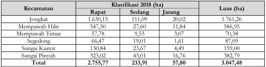
However, in several other sub-districts, areas with medium and sparse vegetation density continued to decline—an indication of growing pressure on the coastal ecosystem, both from natural abrasion and human activities such as land conversion and aquaculture expansion.
Sungai Kunyit: A Coast Squeezed by Development
Sungai Kunyit stands as a vivid example of the tension between development and environmental sustainability. Positioned along an international trade corridor, this area has rapidly transformed into an economic hub. Yet, industrial expansion and infrastructure projects have directly reduced mangrove areas that once thrived along its shoreline.
The study highlights that ecological pressure in Sungai Kunyit is intensifying. Land conversion and coastal erosion have accelerated mangrove loss, making the coastline increasingly vulnerable. This situation underscores how large-scale development without ecological foresight threatens the sustainability of coastal environments.
Grassroots Hope: Community-Based Conservation and Ecotourism
Amid the shrinking mangrove coverage, a beacon of hope emerges from Mempawah Hilir, home to the Mempawah Mangrove Park (MMP). Established in 2011, MMP is a community-managed conservation and ecotourism initiative that engages visitors in mangrove planting and environmental education.
This community-based conservation model demonstrates that local initiatives can both restore coastal ecosystems and generate economic benefits. More importantly, it nurtures ecological awareness among younger generations and strengthens local stewardship of nature.
The Future of Mempawah’s Mangrove
The condition of Mempawah’s mangroves reveals a tale of two realities: on one hand, grassroots conservation efforts have revived optimism; on the other, relentless development continues to erode what remains of this vital ecosystem.
The study shows that the gains achieved between 2018–2021 were insufficient to offset subsequent degradation. While there are pockets of recovery in Segedong and Mempawah Hilir, the renewed decline in 2024 highlights the need for more sustainable and coordinated strategies.
The future of Mempawah’s mangroves depends on collective action—between local governments, academic institutions, and communities. Spatial monitoring systems must be strengthened, and community participation should form the foundation of all conservation policies.
With a balanced approach between development and environmental protection, Mempawah’s mangroves can remain green and strong — a lasting guardian of Borneo’s western coast.
Author: Mohammad R., pegiat Gemawan.